Bedding Area Assessment
Identify likely security cover, mature buck bedding zones and pressure-sensitive areas.
Where Technology Guides Tradition
BuckVisionAI transforms your maps, trail camera photos, weather, wind, terrain and scouting information into actionable property intelligence before you step into the woods.
Excellent movement window
6:00 AM – 10:00 AM
Stand + route recommendations
What You’ll Receive
Identify likely security cover, mature buck bedding zones and pressure-sensitive areas.
Locate high-probability movement routes between bedding, food, water and cover.
Understand which stands match specific winds and when certain setups should be avoided.
Receive ranked stand locations with score, seasonality, access and pressure notes.
Turn camera photos and timestamps into movement patterns and daylight opportunities.
Reduce pressure with smarter entry and exit routes based on terrain and deer movement.
See opportunities for bedding, food plots, screening, water and sanctuary improvements.
A clear property rating that summarizes potential, pressure, movement and opportunity.
See What Hunters Receive
Every report transforms maps, topography, trail camera data and scouting notes into a professional hunting intelligence package.
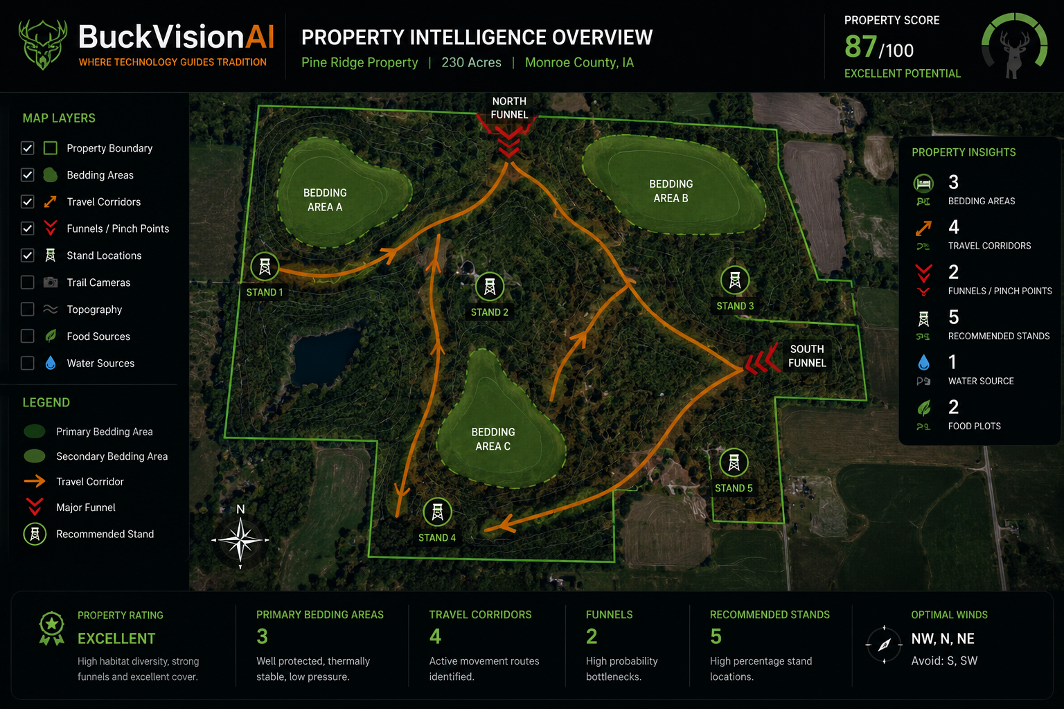
Boundaries, bedding areas, travel corridors, funnels and recommended stands.
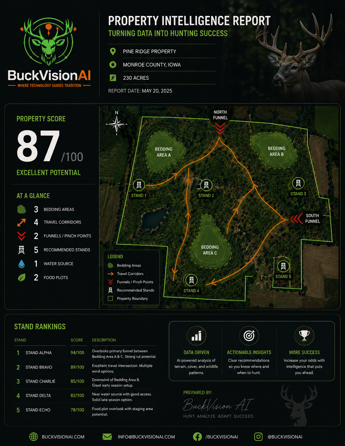
Property score, stand rankings and strategy summary.
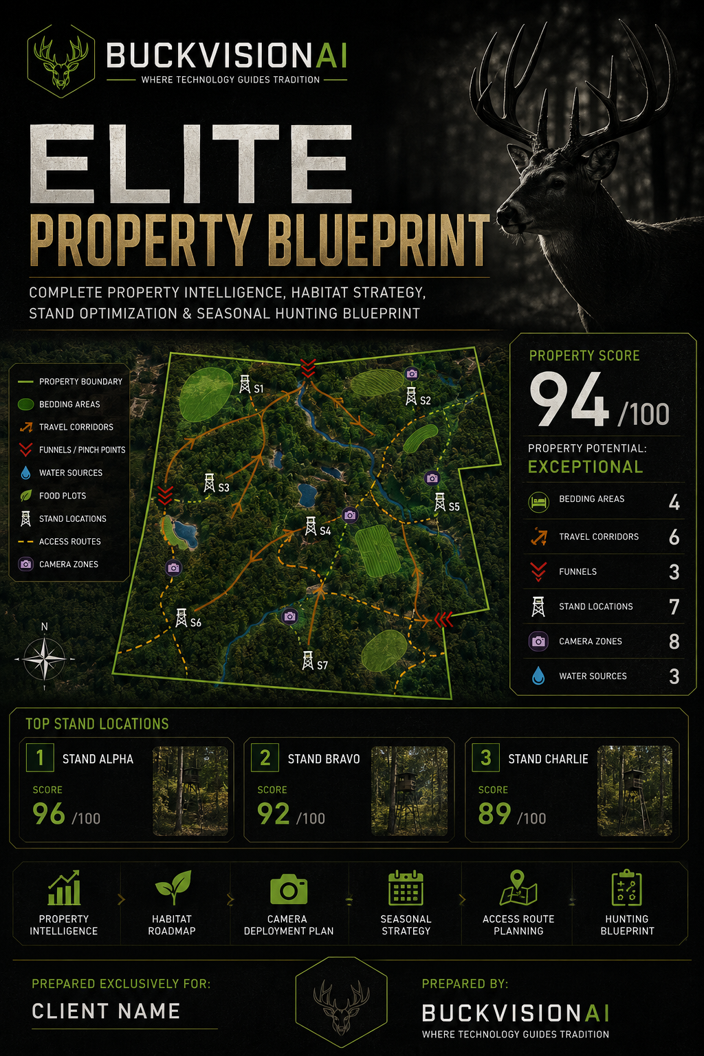
Premium full-property blueprint with habitat and seasonal strategy.
Upload. Analyze. Win.
Send property maps, trail camera photos, scouting notes, stand pins and wind details.
BuckVisionAI reviews your data and builds a hunt intelligence summary.
Receive HuntScore, best stands, access routes and movement recommendations.
Download your plan and export waypoints to onX Hunt, HuntStand, GPX, KML or GeoJSON.
Take your hunt anywhere
Keep your current maps. Add intelligence. BuckVisionAI can package stand locations, camera sites, routes, bedding areas, funnels and recommended hunt zones into common GPS formats.
Stop Guessing. Start Hunting Smarter.
BuckVisionAI transforms your maps, trail camera data and scouting information into actionable hunting intelligence.
$39.99
Essential property intelligence to improve your next hunt.
$99.99
The complete hunting strategy report for serious hunters.
$249.99
The ultimate property blueprint for maximum hunting success.
Secure checkout is handled by Stripe. After purchase, return to BuckVisionAI to submit your analysis details and uploads.
Ready to see your property through a different lens?
Send the information BuckVisionAI needs to create your report. The more detail you provide, the stronger your analysis will be.
Built By Hunters. Powered By Intelligence.
BuckVisionAI combines real-world hunting experience, deer movement analysis, terrain understanding and modern intelligence tools to help hunters make better decisions before they step into the woods.
The BuckVisionAI Founders Collection is being built for hunters who believe in the future of hunting intelligence.
Where Technology Guides Tradition branded shirt planned for the first limited drop.
Hardcore deer skull and BuckVisionAI themed shirt concept for serious whitetail hunters.
Premium patch-style BuckVisionAI hat planned for preorder release.
Contact BuckVisionAI for founding user access, investor interest, partnerships or custom property intelligence.
Upload your property information, maps, trail camera notes, stand locations, and hunting goals. BuckVisionAI turns that information into clear hunting intelligence you can use before you step into the woods.
Supabase-connected login, signup, member dashboard, properties, membership plans, and hunt dashboard foundation.